Nakasendo Post Towns: Walking Magome to Tsumago, Plus Narai-juku and Ouchi-juku
This page contains affiliate links.
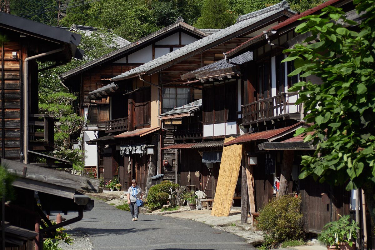
In the Edo period, travelers and lords' processions walked Japan's highways and stopped for the night in post towns, small towns built along the road to give them beds, food and fresh horses. A few of those towns still look much as they did, and walking between two of them on the old stone path is one of the most memorable days you can spend in the Japanese countryside. This guide explains what a post town is, how to walk from Magome to Tsumago, how to send your bags ahead, what to know about bears, and how to add Narai-juku and Ouchi-juku, using the Japan Tourism Agency, Nagano Prefecture, the Agency for Cultural Affairs and the towns' official pages (checked October 2026).
- The short answer: walk about three hours between Magome and Tsumago
- What a post town is
- The Magome to Tsumago walk
- Sending your luggage ahead
- Bears and other safety points
- Narai-juku and Ouchi-juku
- Getting there
The short answer
The classic Nakasendo walk links Magome-juku and Tsumago-juku, two preserved post towns in the Kiso Valley, on a trail of about 9 km that takes roughly three hours. From late March to late November, the towns offer same-day delivery of your bags between them, so you can walk with a light day pack. Bears live in these mountains, so carry a bell or something else that makes noise, walk in daylight and take your food and trash with you. Narai-juku is an easy stop by train on the same JR Chuo Line, and Ouchi-juku, with its thatched roofs, is on a different old road in Fukushima.
What a post town is
The Nakasendo was one of the main highways of the Edo period (1603 to 1868). It ran about 530 km from Edo (now Tokyo) to Kyoto through the mountains of central Japan, with 69 post towns along the way, the Japan Tourism Agency explains. Because it passes through the Kiso Valley, Japanese sources also call it the Kisoji or Kiso Kaido. It carried less traffic than the coastal Tokaido road, but it mattered for sankin kotai, the system that made regional lords travel to Edo every other year (see our guide to the Edo period).
A post town (juku or shukuba) was a stop where official travelers could rest and change horses. Japanese encyclopedias on the honjin describe the main buildings:
Heibonsha's World Encyclopedia on the Kiso road adds that each Kiso post town was a line of 200 to 400 houses along the highway, and that the honjin, waki-honjin and toiya-ba served official travel while the hatago inns and teahouses served everyone else. Encyclopedias also explain that the honjin system became official after sankin kotai was fixed in 1635.
Magome to Tsumago: the classic walk
The two towns sit at the south end of the Kiso Valley, on either side of the Magome Pass, and both became official post towns in 1601.
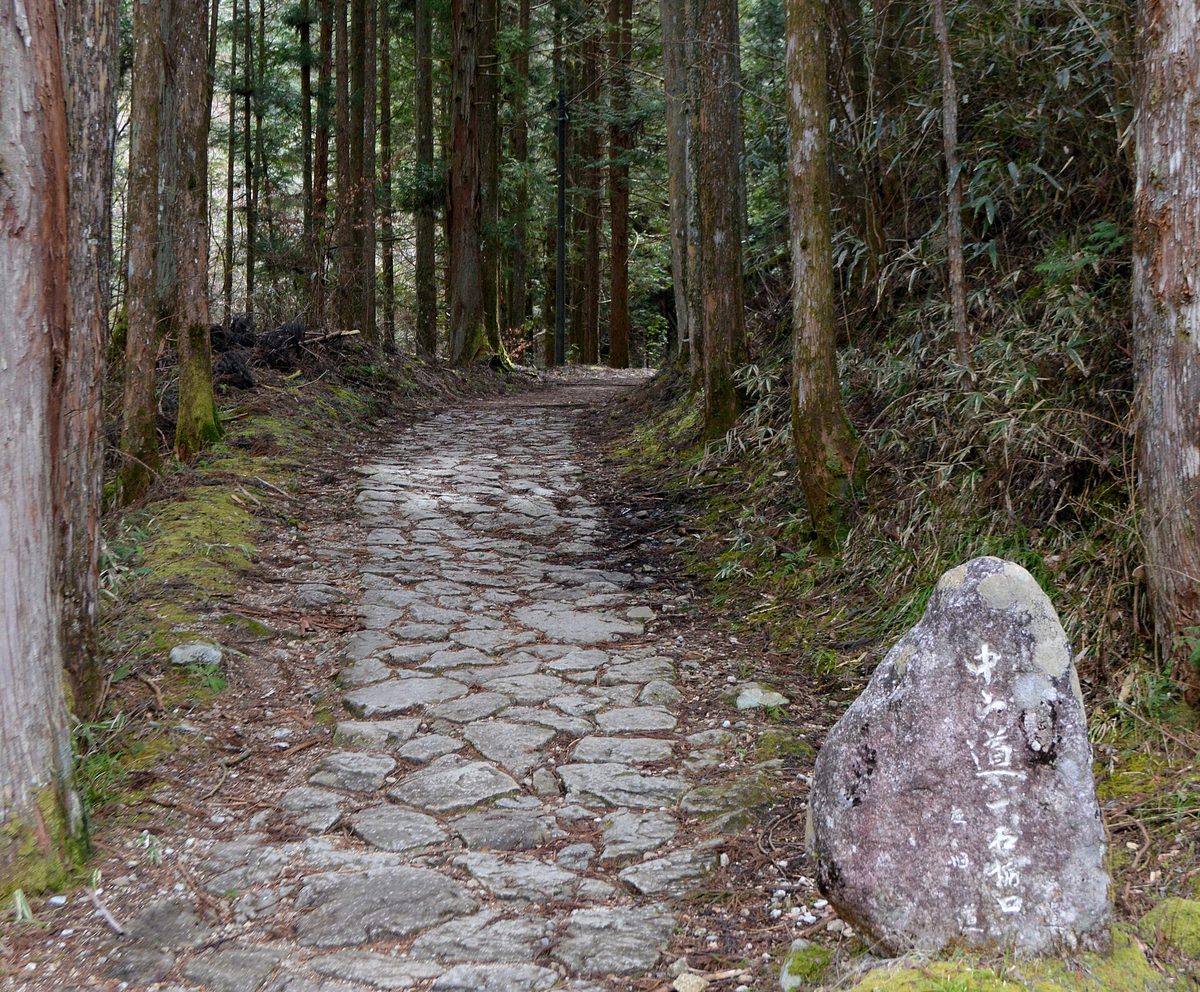
- Magome-juku, Nakatsugawa (Gifu): the southernmost of the eleven Kiso post towns. A survey of 1843 recorded only 69 houses, which made it the smallest of them, according to Heibonsha's World Encyclopedia. The novelist Shimazaki Toson was born here, and it is the setting of his novel Before the Dawn. Magome belonged to a village in Nagano until it joined Nakatsugawa (Gifu) in 2005, which is why the walk crosses a prefectural border.
- Tsumago-juku, Nagiso (Nagano): the 42nd of the 69 post towns. After a new road (1892) and the railway (1909) took its traffic away, it went into slow decline; preservation work began in 1968, and in 1976 it became a preservation district of just under 1,250 hectares that includes the surrounding mountains, the Japan Tourism Agency says. The Agency for Cultural Affairs' district sheet notes that this is about 30 percent of the total area of all such districts in Japan.
The trail between them is about 9 km and takes about three hours, according to JNTO; Nagano Prefecture's tourism site gives 2.5 to 3 hours. JNTO describes it as a walk through cypress forests and farming villages, and parts of it follow the old stone-paved road. Wear shoes with a good grip, since stone paving gets slippery when wet, and plan your start so you finish well before dark.
Sending your luggage ahead
You don't have to carry a suitcase over the pass. Nagano Prefecture's tourism site says that same-day baggage delivery between Tsumago and Magome is available from late March to late November, and that prices are higher from December to mid-March. The service is handled through the towns' tourist information centers; the official pages we checked did not give the current fee or drop-off deadline, so ask at the tourist information center when you arrive, and drop your bags off early in the morning.
If you are moving between cities, you can also send a big suitcase on to your next hotel; our guide to luggage forwarding and coin lockers explains how.
Bears and other safety points
Asian black bears live in the forests of the Kiso Valley. On June 26, 2026, Nagano Prefecture raised its bear advisory for the Kiso area, including Nagiso, to a warning until July 10, after June sightings near homes reached about 2.3 times the usual number. In autumn, the prefecture's leaflet warns, bears search for food all day to prepare for winter. Its advice for people going into the mountains:
- Avoid early morning and evening, when bears are most active.
- Carry something that makes noise, such as a bear bell, a radio or a whistle, so bears hear you first and move away.
- Take all food and trash home with you; a bear that learns the taste of human food keeps coming back.
- If you meet a bear, don't shout and don't run. Back away slowly, and never feed it or go near it.
- If a bear attacks, the prefecture's last-resort advice is to lie face down with your hands clasped behind your neck and keep your backpack on.
- Report a sighting to the local town office or the police.
Check Nagano Prefecture's bear page (in Japanese) and ask at the tourist information center about recent sightings before you set off.
Narai-juku: the long post town below Torii Pass
Narai-juku in Shiojiri (Nagano) lies at the northern foot of Torii Pass, a hard climb for travelers on the Kiso road. Japanese encyclopedias on Narai describe it as the highest post town on the Nakasendo and record that in 1843 it had 409 houses, including woodworkers and lacquerware makers as well as the inns. Its old street runs for about 1 km, and Nagano Prefecture's tourism site calls it the longest post town on the Nakasendo. Many houses have the upper floor projecting over the street (dashibari-zukuri), the Agency for Cultural Affairs' district sheet notes; the town became a preservation district in 1978.
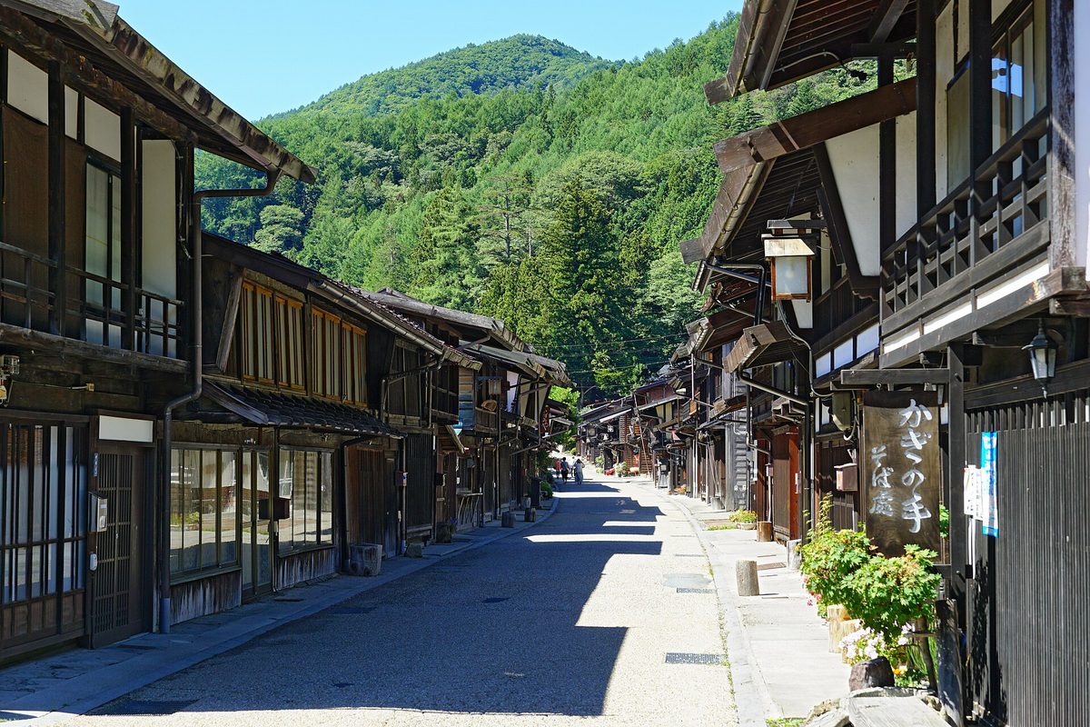
Narai is the easiest of these towns to reach: take the JR Chuo Line to Narai Station, and the old street begins a short walk away. Walkers can also cross Torii Pass (1,197 m) on the old road to the next post town, Yabuhara.
Ouchi-juku: thatched roofs on the road to Aizu
Ouchi-juku in Shimogo (Fukushima) is not on the Nakasendo but on the Shimotsuke Kaido, also called the Aizu-Nishi Kaido, one of the roads the Aizu domain built in the Edo period. Shimogo Town explains that it was the third post town from the castle town of Wakamatsu, and that its people ran the post station and farmed at the same time. The road lost its main traffic after a new national road took another route in 1884. Today 44 main houses with thick thatched roofs face the old road with their gable ends, and the town became a preservation district in 1981.
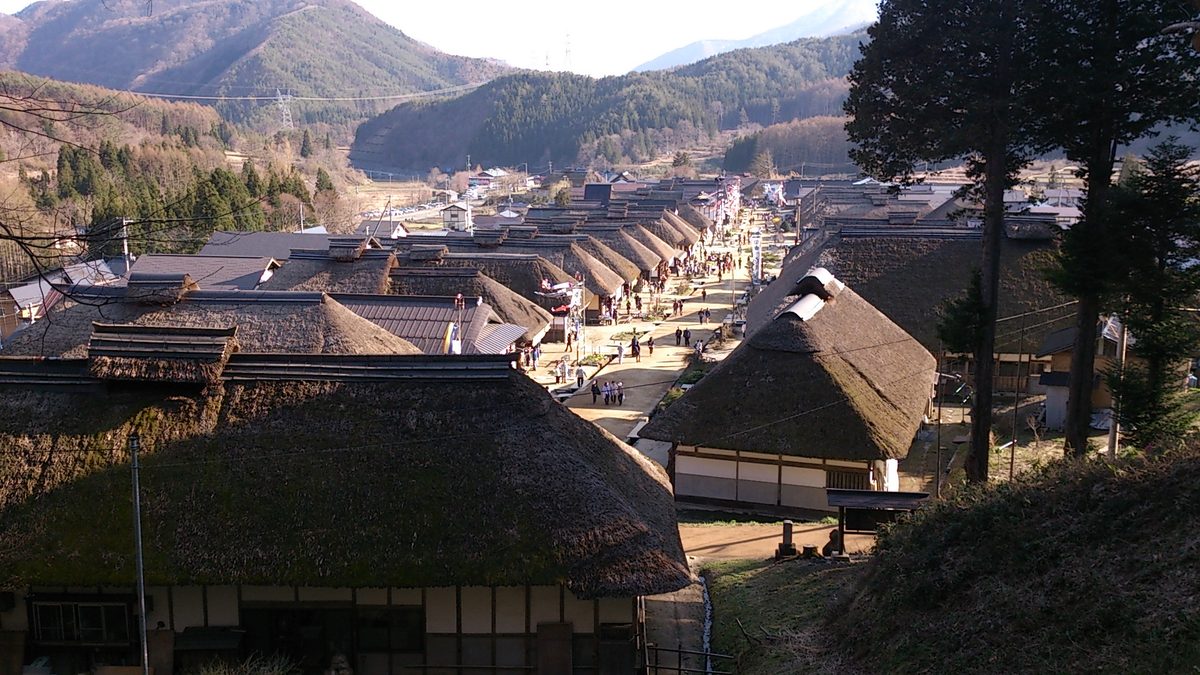
The Japan Tourism Agency says the town is thought to have been established around 1640, that neighbors still repair each other's thatch under a system of mutual help called yui, and that the Midsummer Festival is held on July 2 and the Snow Festival on the second weekend of February. Try the local soba eaten with a long green onion instead of chopsticks, which Fukushima Prefecture also introduces.
Getting there
The JR Chuo Line runs alongside the Kiso road, so all three Nakasendo towns are reached from its stations, according to Nagano Prefecture's tourism site. For Ouchi-juku, the nearest station is Yunokami-Onsen on the Aizu Railway, says the railway company.
JNTO notes that buses from Nagiso Station to Tsumago are infrequent but taxis are available. At Yunokami-Onsen, the station building itself has a thatched roof, and the Aizu Railway points visitors to the Saruyu-go bus; check its season and times locally, or take a taxi.
Manners in a living town
These are not open-air museums. The Japan Tourism Agency notes that many of the houses in Ouchi-juku are run by families who have lived there for generations, and the same is true along the Nakasendo. A few simple habits help:
- Don't walk into houses, gardens or back lanes unless a sign or the owner invites you in.
- Keep your voice down early in the morning and in the evening, when residents are at home.
- Take your trash with you; on the trail, it also keeps bears away.
What to do on your trip
- Pick your base and your direction, and check the bus times at Nakatsugawa or Nagiso the day before.
- From late March to late November, ask the tourist information center in the morning about sending your bags to the other town.
- Pack a bear bell, water, a rain jacket and good shoes, and set off early enough to finish in daylight.
- If you have another day, add Narai-juku by train, or plan a separate trip to Ouchi-juku in Fukushima.
Last reviewed: October 25, 2026. Luggage service seasons, bus times and bear warnings change, so check the official pages below and ask locally before you walk.
References
- Japan Tourism Agency: Tsumago (English)
- Japan Tourism Agency: Ouchi-juku (English)
- JNTO: Tsumago (English)
- Go! NAGANO (Nagano Prefecture's tourism site): The Nakasendo trail guide (English)
- Nagano Prefecture: Bear warning for the Kiso area, June 26, 2026 (Japanese, PDF)
- Nagano Prefecture: Watch out for bears in autumn (Japanese, PDF)
- Nagano Prefecture: About Asian black bears (Japanese)
- Agency for Cultural Affairs: Tsumago-juku preservation district (Japanese, PDF)
- Agency for Cultural Affairs: Narai preservation district (Japanese, PDF)
- Kotobank: Honjin (Japanese)
- Kotobank: Kisoji, the Kiso road (Japanese)
- Kotobank: Magome (Japanese)
- Kotobank: Narai (Japanese)
- Shimogo Town: Ouchi-juku preservation district (Japanese)
- Fukushima Prefecture: Minami-Aizu model course (English)
- Aizu Railway: Ouchi-juku (Japanese)